Geolocate

Worabe topographic map

Click on the map to display elevation.

About this map

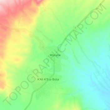
Name: Worabe topographic map, elevation, terrain.

Location: Worabe, Guraghe, Southern Nations, Ethiopia (7.81345 38.14730 7.89345 38.22730)

Average elevation: 6,936 ft

Minimum elevation: 6,398 ft

Maximum elevation: 8,022 ft

Gear up for your next adventure:

🚁Photography Drones - Capture stunning aerial views of landforms and topography
🗺️NatGeo Topo Maps - High-quality waterproof printed topographic maps of US Parks
🪑Portable Camp Table - Compact table for campsite meals
📚USA Hiking Guide Books - Top trail guides and map books
🌧️Backpack Rain Cover - Keep gear dry in wet weather

As an Amazon Associate, this site earns from qualifying purchases at no extra cost to you.