
Make a donation
Gear up for your next adventure:
As an Amazon Associate, this site earns from qualifying purchases at no extra cost to you.
Stuvenborn topographic map
Click on the map to display elevation.
Make a donation
Gear up for your next adventure:
As an Amazon Associate, this site earns from qualifying purchases at no extra cost to you.
About this map
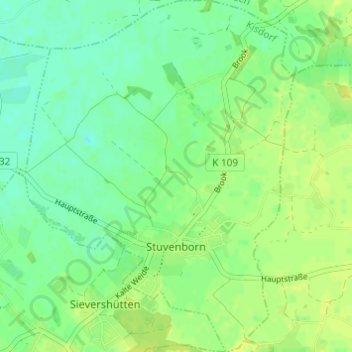
Name: Stuvenborn topographic map, elevation, terrain.
Average elevation: 89 ft
Minimum elevation: 62 ft
Maximum elevation: 112 ft
Make a donation
Gear up for your next adventure:
As an Amazon Associate, this site earns from qualifying purchases at no extra cost to you.
Other topographic maps
Click on a map to view its topography, its elevation and its terrain.
Götzberg
Deutschland > Schleswig-Holstein > Kreis Segeberg > Henstedt-Ulzburg
Die Schleswig-Holstein-Topographie listet als Ortsteile folgende auf: Westerwohld, Vogelsang, Götzberg, Stegelkamp, Hohnerberg, Wohld, Henstedterbaum, Ellerrehm, Birkenau, Drögeneck, Horst, Hohenhorst, Rhen, Togenkamp, Ulzburg-Süd, Beckershof.
Average elevation: 161 ft
Norderstedt
Deutschland > Schleswig-Holstein > Kreis Segeberg > Norderstedt > Norderstedt
Average elevation: 105 ft
Make a donation
Gear up for your next adventure:
As an Amazon Associate, this site earns from qualifying purchases at no extra cost to you.
Kattendorf-Weeden
Deutschland > Schleswig-Holstein > Kreis Segeberg > Kattendorf
Average elevation: 174 ft
Make a donation
Gear up for your next adventure:
As an Amazon Associate, this site earns from qualifying purchases at no extra cost to you.
Vogelsang
Deutschland > Schleswig-Holstein > Kreis Segeberg > Henstedt-Ulzburg > Götzberg
Average elevation: 161 ft
Kalkberg
Deutschland > Schleswig-Holstein > Kreis Segeberg > Bad Segeberg
Ursprünglich war der Kalkberg deutlich über 110 Meter hoch und hatte eine völlig andere Gestalt als heute. Im Mittelalter stand auf dem einstigen Rücken des damals noch Alberg genannten Berges die Siegesburg. Diese Höhenburg wurde von Kaiser Lothar 1134 gegründet und im Dreißigjährigen Krieg von den…
Average elevation: 148 ft
Strand Seekamp
Deutschland > Schleswig-Holstein > Kreis Segeberg > Berlin > Seekamp
Average elevation: 125 ft
Make a donation
Gear up for your next adventure:
As an Amazon Associate, this site earns from qualifying purchases at no extra cost to you.
Make a donation
Gear up for your next adventure:
As an Amazon Associate, this site earns from qualifying purchases at no extra cost to you.