
Make a donation
Gear up for your next adventure:
As an Amazon Associate, this site earns from qualifying purchases at no extra cost to you.
Mont Terri topographic map
Click on the map to display elevation.
Make a donation
Gear up for your next adventure:
As an Amazon Associate, this site earns from qualifying purchases at no extra cost to you.
Mont Terri
Le laboratoire souterrain du Mont-Terri, accessible via le tunnel du Mont Terri (autoroute A16, Transjurane) traversant le massif, est géré par Swisstopo (Office fédéral suisse de topographie). Il est situé dans la formation de l'argile à Opalinus. Les recherches relatives au stockage des déchets radioactifs en couche géologique profonde sont pilotées par la NAGRA et par un consortium international de 22 pays. Le projet est également soutenu scientifiquement par les organismes scientifiques membres du « Club Argile » (Clay Club) de l'Agence pour l'énergie nucléaire (AEN) de l'OCDE. Les activités du laboratoire souterrain se sont également étendues aux recherches relatives à l'usage des ressources du sous-sol comme l'injection de CO2 à grande profondeur ou la géothermie profonde.
Make a donation
Gear up for your next adventure:
As an Amazon Associate, this site earns from qualifying purchases at no extra cost to you.
About this map
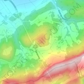
Name: Mont Terri topographic map, elevation, terrain.
Location: Mont Terri, Cornol, District de Porrentruy, Jura, 2952, Suisse (47.39157 7.16122 47.39167 7.16132)
Average elevation: 2,192 ft
Minimum elevation: 1,640 ft
Maximum elevation: 3,012 ft
Make a donation
Gear up for your next adventure:
As an Amazon Associate, this site earns from qualifying purchases at no extra cost to you.