
Esenguly etraby topographic map
Interactive map
Click on the map to display elevation.
About this map
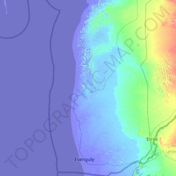
Name: Esenguly etraby topographic map, elevation, terrain.
Location: Esenguly etraby, Balkan, 800245, Turkménistan (37.31999 53.56088 38.93902 54.67861)
Average elevation: -7 ft
Minimum elevation: -95 ft
Maximum elevation: 866 ft
Other topographic maps
Click on a map to view its topography, its elevation and its terrain.
Île Ogurchinskiy
Île Ogurchinskiy, Balkan, Turkménistan
Average elevation: -95 ft