Geolocate

Chablis topographic map

Click on the map to display elevation.

About this map
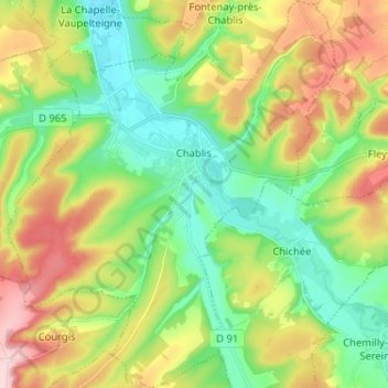
Name: Chablis topographic map, elevation, terrain.

Location: Chablis, Auxerre, Yonne, Bourgogne – Franche-Comté, Metropolitan France, 89800, France (47.76262 3.73851 47.84915 3.84773)

Average elevation: 663 ft

Minimum elevation: 404 ft

Maximum elevation: 1,086 ft

Other topographic maps

Click on a map to view its topography, its elevation and its terrain.

Les Huees

France > Bourgogne – Franche-Comté > Yonne > Tonnerre

Average elevation: 748 ft

Sixte

France > Bourgogne – Franche-Comté > Yonne > Michery

Average elevation: 230 ft

Anus

France > Bourgogne – Franche-Comté > Yonne > Fouronnes

Average elevation: 758 ft

L'Ormeau

France > Bourgogne – Franche-Comté > Yonne > Vaudeurs

Average elevation: 705 ft

Bapaume

France > Bourgogne – Franche-Comté > Yonne > Dollot

Average elevation: 489 ft

Crai

France > Bourgogne – Franche-Comté > Yonne > Chamoux

Average elevation: 807 ft

Gear up for your next adventure:

🎁Geography Themed Gifts - Unique gift ideas for map lovers and geography enthusiasts
📱Solar Portable Charger - Solar power bank for charging devices off‑grid
🛌Ultralight Sleeping Bags - Compact down bags for cold nights in the wilderness
🔥Camping Stove - Portable stove for camping and backcountry cooking
🧴Hand Sanitizer - Keep hands clean while hiking

As an Amazon Associate, this site earns from qualifying purchases at no extra cost to you.