Geolocate

Constance Lake topographic map

Click on the map to display elevation.

About this map
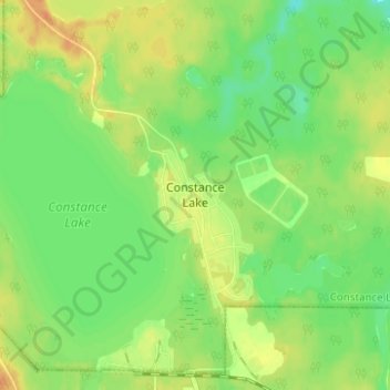
Name: Constance Lake topographic map, elevation, terrain.

Location: Constance Lake, Cochrane District, Northeastern Ontario, Ontario, P0L 1B0, Canada (49.78756 -84.15824 49.82756 -84.11824)

Average elevation: 797 ft

Minimum elevation: 741 ft

Maximum elevation: 853 ft

Other topographic maps

Click on a map to view its topography, its elevation and its terrain.

Lac Abitibi

Canada > Ontario > Cochrane District

Average elevation: 955 ft

Hearst

Canada > Ontario > Cochrane District

Average elevation: 814 ft

Timmins

Canada > Ontario > Cochrane District

Average elevation: 991 ft

Moosonee

Canada > Ontario > Cochrane District

Average elevation: 43 ft

Kapuskasing

Canada > Ontario > Cochrane District

Average elevation: 745 ft

Gear up for your next adventure:

🥇GPS Hiking Watch - Multi‑sport GPS watch with navigation and trail tracking
⌚Solar GPS Watches - Advanced multisport watches with built-in topographic maps
🛠️Backpacking Tool Kit - Essential toolkit for outdoor repairs
📡Handheld GPS Device - Reliable handheld GPS for outdoor navigation
🛌Ultralight Sleeping Bags - Compact down bags for cold nights in the wilderness

As an Amazon Associate, this site earns from qualifying purchases at no extra cost to you.