
Make a donation
Gear up for your next adventure:
As an Amazon Associate, this site earns from qualifying purchases at no extra cost to you.
Jaworze topographic map
Click on the map to display elevation.
Make a donation
Gear up for your next adventure:
As an Amazon Associate, this site earns from qualifying purchases at no extra cost to you.
Jaworze
The Polish name is of topographic origins and is derived from sycamore trees (Polish: jawor. German name is a composition of a personal name Ern(st) and dorf (German: a village).
Make a donation
Gear up for your next adventure:
As an Amazon Associate, this site earns from qualifying purchases at no extra cost to you.
About this map
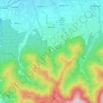
Name: Jaworze topographic map, elevation, terrain.
Average elevation: 1,713 ft
Minimum elevation: 1,066 ft
Maximum elevation: 3,386 ft
Make a donation
Gear up for your next adventure:
As an Amazon Associate, this site earns from qualifying purchases at no extra cost to you.
Other topographic maps
Click on a map to view its topography, its elevation and its terrain.