
Topaz Lake topographic map
Click on the map to display elevation.
About this map
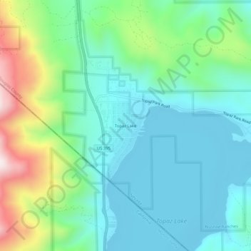
Name: Topaz Lake topographic map, elevation, terrain.
Location: Topaz Lake, Douglas County, Nevada, United States (38.67541 -119.56800 38.71541 -119.52800)
Average elevation: 5,709 ft
Minimum elevation: 4,967 ft
Maximum elevation: 7,608 ft
Douglas County trails, hiking, mountain biking, running and outdoor activities
Other topographic maps
Click on a map to view its topography, its elevation and its terrain.
Gardnerville Ranchos
United States > Nevada > Douglas County > Gardnerville Ranchos
Average elevation: 4,826 ft