
Make a donation
Gear up for your next adventure:
As an Amazon Associate, this site earns from qualifying purchases at no extra cost to you.
Provincia de Huaura topographic map
Click on the map to display elevation.
Make a donation
Gear up for your next adventure:
As an Amazon Associate, this site earns from qualifying purchases at no extra cost to you.
About this map
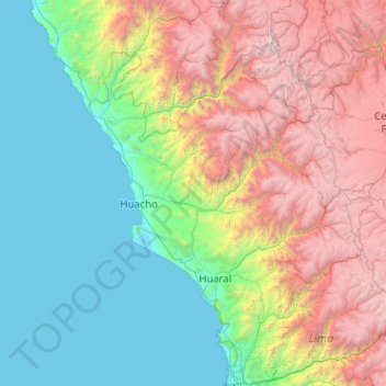
Name: Provincia de Huaura topographic map, elevation, terrain.
Location: Provincia de Huaura, Sayán, Huaura, Lima, Perú (-11.07124 -77.34182 -11.03124 -77.30182)
Average elevation: 2,874 ft
Minimum elevation: 1,991 ft
Maximum elevation: 4,367 ft
Make a donation
Gear up for your next adventure:
As an Amazon Associate, this site earns from qualifying purchases at no extra cost to you.
Other topographic maps
Click on a map to view its topography, its elevation and its terrain.
Sayán
La Comunidad Campesina de Sayán, se encuentra ubicada en la Región Lima, Provincia de Huaura, Distrito de Sayán. En la Región Costa y parte de la región Interandina con respecto a la región Costa sus límites se encuentran inscritos en el tomo 47 fojas del 77 al 79 de la partida electrónica Nº 8005504…
Average elevation: 4,852 ft