Geolocate

Nijmegen topographic map

Click on the map to display elevation.

About this map
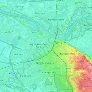
Name: Nijmegen topographic map, elevation, terrain.

Location: Nijmegen, Gelderland, Netherlands (51.79059 5.75762 51.89462 5.90835)

Average elevation: 62 ft

Minimum elevation: 10 ft

Maximum elevation: 312 ft

Other topographic maps

Click on a map to view its topography, its elevation and its terrain.
Nijmegen

Netherlands > Gelderland > Nijmegen

Average elevation: 52 ft

Kops Plateau

Netherlands > Gelderland > Nijmegen

Average elevation: 118 ft

Gear up for your next adventure:

👟Men's Trail Runners - Lightweight footwear for fast-paced exploration and light hiking
🗺️Topographic Maps - Detailed topo maps for hiking, exploring and outdoor navigation
🪓Survival Multi‑Tool - Versatile tool for camp and trail tasks
🗃️Trail First Aid Kit - Essential kit for outdoor injuries and emergencies
🚁Photography Drones - Capture stunning aerial views of landforms and topography

As an Amazon Associate, this site earns from qualifying purchases at no extra cost to you.