Geolocate

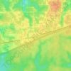
DeFuniak Springs topographic map

Click on the map to display elevation.

About this map
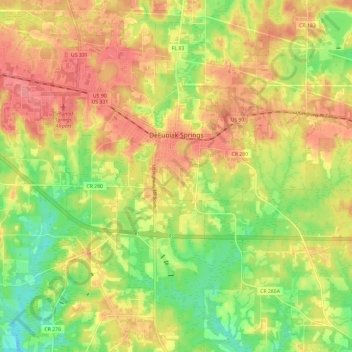
Name: DeFuniak Springs topographic map, elevation, terrain.

Location: DeFuniak Springs, Walton County, Florida, 32435, United States (30.65812 -86.16718 30.75985 -86.08571)

Average elevation: 184 ft

Minimum elevation: 52 ft

Maximum elevation: 295 ft

Walton County trails, hiking, mountain biking, running and outdoor activities

Other topographic maps

Click on a map to view its topography, its elevation and its terrain.
Santa Rosa Beach

United States > Florida > Walton County

Average elevation: 13 ft

Alys Beach

United States > Florida > Walton County

Average elevation: 16 ft

Seaside

United States > Florida > Walton County

Average elevation: 16 ft

Lakewood

United States > Florida > Walton County

Average elevation: 292 ft

Rosemary Beach

United States > Florida > Walton County

Average elevation: 20 ft

Britton Hill

United States > Florida > Walton County

Britton Hill is the highest natural point in the state of Florida, United States, with a summit elevation of 345 feet (105 meters) above mean sea level. Britton Hill is the lowest state highpoint in the United States, 103 feet (31 m) lower than the next lowest highpoint, Ebright Azimuth in Delaware, and far…

Average elevation: 305 ft
Seagrove Beach

United States > Florida > Walton County > Seaside

Average elevation: 16 ft

Villa Tasso

United States > Florida > Walton County

Average elevation: 16 ft

Point Washington

United States > Florida > Walton County

Average elevation: 13 ft

Seacrest Beach

United States > Florida > Walton County

Average elevation: 20 ft

Miramar Beach

United States > Florida > Walton County

Average elevation: 7 ft

Choctaw Beach

United States > Florida > Walton County

Average elevation: 23 ft

Grosh

United States > Florida > Walton County

Average elevation: 10 ft

Britton Hill

United States > Florida > Walton County

Britton Hill is the highest natural point in the state of Florida, United States, with a summit elevation of 345 ft (105 m) above mean sea level. Britton Hill is the lowest state highpoint in the United States, 103 ft (31 m) lower than the second-lowest U.S. state highpoint, Ebright Azimuth in Delaware.

Average elevation: 305 ft

Santa Rosa Beach

United States > Florida > Walton County

Average elevation: 13 ft

Sandestin

United States > Florida > Walton County

Average elevation: 10 ft

Miramar Beach

United States > Florida > Walton County

Average elevation: 7 ft

Seacrest Beach

United States > Florida > Walton County

Average elevation: 20 ft

Alys Beach

United States > Florida > Walton County

Average elevation: 16 ft

Miramar Beach

United States > Florida > Walton County

Average elevation: 7 ft

Seaside

United States > Florida > Walton County

Average elevation: 16 ft

Britton Hill

United States > Florida > Walton County

Britton Hill is the highest natural point in the state of Florida, United States, with a summit elevation of 345 feet (105 meters) above mean sea level. Britton Hill is the lowest state highpoint in the United States, 103 feet (31 m) lower than the next lowest highpoint, Ebright Azimuth in Delaware, and far…

Average elevation: 305 ft
Santa Rosa Beach

United States > Florida > Walton County

Average elevation: 13 ft

Rosemary Beach

United States > Florida > Walton County

Average elevation: 20 ft

Miramar Beach

United States > Florida > Walton County

Average elevation: 7 ft

Point Washington

United States > Florida > Walton County

Average elevation: 13 ft

Alys Beach

United States > Florida > Walton County

Average elevation: 16 ft

Mossy Head

United States > Florida > Walton County

Average elevation: 249 ft

Redbay

United States > Florida > Walton County

Average elevation: 105 ft

Gear up for your next adventure:

🪵Folding Camp Saw - Compact saw for wood and campsite work
🔭Compact Binoculars - HD vision for scouting terrain and identifying distant landmarks
🪶Camp Gear Gift Set - Perfect gift bundle for outdoor fans
🔋Solar Power Banks - Keep your GPS and phone charged in remote wilderness areas
🚁Photography Drones - Capture stunning aerial views of landforms and topography

As an Amazon Associate, this site earns from qualifying purchases at no extra cost to you.