
Thank you for supporting this site ❤️
Make a donation
Make a donation
Gear up for your next adventure:
As an Amazon Associate, this site earns from qualifying purchases at no extra cost to you.
Glenlivet topographic map
Click on the map to display elevation.
Thank you for supporting this site ❤️
Make a donation
Make a donation
Gear up for your next adventure:
As an Amazon Associate, this site earns from qualifying purchases at no extra cost to you.
About this map
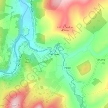
Name: Glenlivet topographic map, elevation, terrain.
Location: Glenlivet, Moray, Scotland, AB37 9BT, United Kingdom (57.33196 -3.35808 57.37196 -3.31808)
Average elevation: 919 ft
Minimum elevation: 581 ft
Maximum elevation: 1,483 ft
Thank you for supporting this site ❤️
Make a donation
Make a donation
Gear up for your next adventure:
As an Amazon Associate, this site earns from qualifying purchases at no extra cost to you.