Geolocate

Tibshelf topographic map

Click on the map to display elevation.

About this map

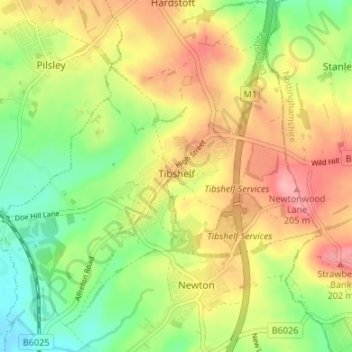
Name: Tibshelf topographic map, elevation, terrain.

Location: Tibshelf, Bolsover, Derbyshire, England, United Kingdom (53.12246 -1.37783 53.16260 -1.31884)

Average elevation: 499 ft

Minimum elevation: 322 ft

Maximum elevation: 689 ft

Gear up for your next adventure:

🧭Compass with Lanyard - Easy‑carry compass for navigation
🕶️GPS Smartphone Mount - Secure mount for phone navigation
🏔️Mountain Trail Maps - High‑detail maps for popular peaks
🛏️Cold Weather Sleeping Bag - Warm sleeping bag for cold conditions
🥇GPS Hiking Watch - Multi‑sport GPS watch with navigation and trail tracking

As an Amazon Associate, this site earns from qualifying purchases at no extra cost to you.