
Make a donation
Gear up for your next adventure:
As an Amazon Associate, this site earns from qualifying purchases at no extra cost to you.
Folgosa topographic map
Click on the map to display elevation.
Make a donation
Gear up for your next adventure:
As an Amazon Associate, this site earns from qualifying purchases at no extra cost to you.
About this map
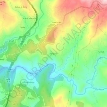
Name: Folgosa topographic map, elevation, terrain.
Location: Folgosa, Castro Daire, Viseu, 3600-143, Portugal (40.87488 -7.91808 40.91488 -7.87808)
Average elevation: 1,955 ft
Minimum elevation: 1,512 ft
Maximum elevation: 2,644 ft
Make a donation
Gear up for your next adventure:
As an Amazon Associate, this site earns from qualifying purchases at no extra cost to you.
Other topographic maps
Click on a map to view its topography, its elevation and its terrain.
Make a donation
Gear up for your next adventure:
As an Amazon Associate, this site earns from qualifying purchases at no extra cost to you.
Santuário de Nossa senhora da Ouvida
Portugal > Viseu > Castro Daire > Monteiras
Average elevation: 2,759 ft
Monteiras
Portugal > Viseu > Castro Daire
A freguesia de Monteiras fica situada entre os planaltos de Montemuro e Leomil, a cerca de 920 metros de altitude.
Average elevation: 2,946 ft
Make a donation
Gear up for your next adventure:
As an Amazon Associate, this site earns from qualifying purchases at no extra cost to you.
Make a donation
Gear up for your next adventure:
As an Amazon Associate, this site earns from qualifying purchases at no extra cost to you.