
Make a donation
Gear up for your next adventure:
As an Amazon Associate, this site earns from qualifying purchases at no extra cost to you.
Goeferdinge topographic map
Click on the map to display elevation.
Make a donation
Gear up for your next adventure:
As an Amazon Associate, this site earns from qualifying purchases at no extra cost to you.
Goeferdinge
Het dorp ligt in Zandlemig Vlaanderen in de Denderstreek en aan de Molenbeek, in een golvend landschap waarvan de hoogte varieert van 25 m tot 62 m. Het dorp ligt landelijk, ten westen van Geraardsbergen, maar is door lintbebouwing met Overboelare en het stadscentrum verbonden geraakt.
Make a donation
Gear up for your next adventure:
As an Amazon Associate, this site earns from qualifying purchases at no extra cost to you.
About this map
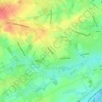
Name: Goeferdinge topographic map, elevation, terrain.
Average elevation: 135 ft
Minimum elevation: 52 ft
Maximum elevation: 236 ft
Make a donation
Gear up for your next adventure:
As an Amazon Associate, this site earns from qualifying purchases at no extra cost to you.
Other topographic maps
Click on a map to view its topography, its elevation and its terrain.