
Thank you for supporting this site ❤️
Make a donation
Make a donation
Gear up for your next adventure:
As an Amazon Associate, this site earns from qualifying purchases at no extra cost to you.
Rossão topographic map
Click on the map to display elevation.
Thank you for supporting this site ❤️
Make a donation
Make a donation
Gear up for your next adventure:
As an Amazon Associate, this site earns from qualifying purchases at no extra cost to you.
About this map
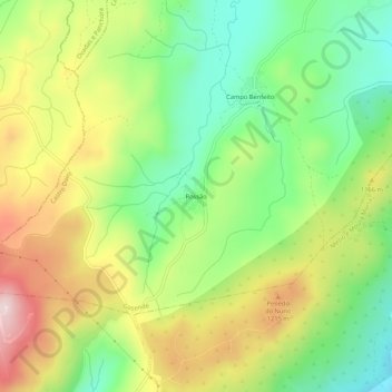
Name: Rossão topographic map, elevation, terrain.
Location: Rossão, Gosende, Castro Daire, Viseu, Portugal (40.96656 -7.95479 41.00656 -7.91479)
Average elevation: 3,596 ft
Minimum elevation: 3,048 ft
Maximum elevation: 4,331 ft
Thank you for supporting this site ❤️
Make a donation
Make a donation
Gear up for your next adventure:
As an Amazon Associate, this site earns from qualifying purchases at no extra cost to you.