Geolocate

Plön topographic map

Click on the map to display elevation.

About this map

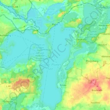
Name: Plön topographic map, elevation, terrain.

Location: Plön, Kreis Plön, Schleswig-Holstein, 24306, Germany (54.08196 10.33037 54.17965 10.49508)

Average elevation: 112 ft

Minimum elevation: 49 ft

Maximum elevation: 299 ft

Other topographic maps

Click on a map to view its topography, its elevation and its terrain.

Heidkate

Germany > Schleswig-Holstein > Kreis Plön > Wisch

Average elevation: -3 ft

Gear up for your next adventure:

🗺️Topographic Maps - Detailed topo maps for hiking, exploring and outdoor navigation
🪶Thermal Camp Blanket - Extra warmth for cold nights
🧭Hiking Compass - Precision compass for reliable navigation in the wilderness
📌Outdoor GPS Map App - Apps and devices for digital topographic navigation
🪶Compact Camp Shovel - Folding shovel for campsite tasks

As an Amazon Associate, this site earns from qualifying purchases at no extra cost to you.