Geolocate

Carters Lake topographic map

Click on the map to display elevation.

About this map

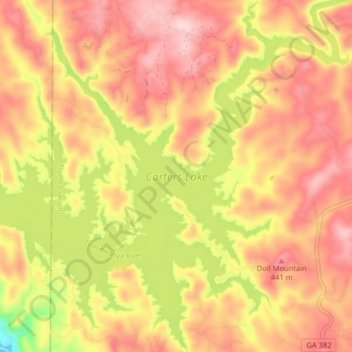
Name: Carters Lake topographic map, elevation, terrain.

Location: Carters Lake, Gilmer County, Georgia, United States (34.58811 -84.67356 34.65417 -84.60089)

Average elevation: 1,214 ft

Minimum elevation: 689 ft

Maximum elevation: 1,542 ft

Gilmer County trails, hiking, mountain biking, running and outdoor activities

Other topographic maps

Click on a map to view its topography, its elevation and its terrain.

Dyke

United States > Georgia > Gilmer County

Average elevation: 1,667 ft

Big Bald Mountain

United States > Georgia > Gilmer County

Average elevation: 3,350 ft

Yukon

United States > Georgia > Gilmer County

Average elevation: 1,558 ft

Lucius

United States > Georgia > Gilmer County

Average elevation: 1,755 ft

White Cliffs

United States > Georgia > Gilmer County

Average elevation: 2,733 ft

Cherry Log

United States > Georgia > Gilmer County

Average elevation: 1,713 ft

Gear up for your next adventure:

🧺Microfiber Travel Towels - Compact and fast-drying towels for trail use
📱Heavy-Duty Phone Cases - Drop-proof and waterproof protection for outdoor navigation
📦Dry Bags Set - Waterproof storage for electronics and clothes
🪶Trail Camera - Capture wildlife on your hikes
☀️Outdoor Sunscreen - High protection sunscreen for outdoor activities

As an Amazon Associate, this site earns from qualifying purchases at no extra cost to you.