
Make a donation
Gear up for your next adventure:
As an Amazon Associate, this site earns from qualifying purchases at no extra cost to you.
Koisdorf topographic map
Click on the map to display elevation.
Make a donation
Gear up for your next adventure:
As an Amazon Associate, this site earns from qualifying purchases at no extra cost to you.
About this map
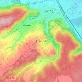
Name: Koisdorf topographic map, elevation, terrain.
Average elevation: 486 ft
Minimum elevation: 180 ft
Maximum elevation: 771 ft
Make a donation
Gear up for your next adventure:
As an Amazon Associate, this site earns from qualifying purchases at no extra cost to you.
Other topographic maps
Click on a map to view its topography, its elevation and its terrain.
Bad Bodendorf
Deutschland > Rheinland-Pfalz > Landkreis Ahrweiler > Sinzig
Bad Bodendorf liegt am unteren Verlauf der Ahr im Tal. Im Norden und Süden ist es von den Anhöhen umgeben, nordwestlich liegt der Reisberg und südwestlich der Mühlenberg, welche eine letzte engere Stelle vor dem Rheintal bilden.
Average elevation: 420 ft