Geolocate

Van topographic map

Click on the map to display elevation.

About this map

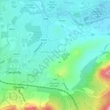
Name: Van topographic map, elevation, terrain.

Location: Van, Caerphilly County Borough, Wales, United Kingdom (51.56842 -3.21618 51.58904 -3.17648)

Average elevation: 315 ft

Minimum elevation: 190 ft

Maximum elevation: 735 ft

Other topographic maps

Click on a map to view its topography, its elevation and its terrain.

Risca

United Kingdom > Wales > Caerphilly County Borough

Average elevation: 502 ft

Gear up for your next adventure:

🚑Emergency Bivvies - Heat-reflective sleeping bags for survival situations
🏔️Mountain Trail Maps - High‑detail maps for popular peaks
🗺️Topographic Maps - Detailed topo maps for hiking, exploring and outdoor navigation
📡Handheld GPS Device - Reliable handheld GPS for outdoor navigation
🧢Sun Protection Hats - Wide-brimmed and UPF-rated hats for high-altitude sun safety

As an Amazon Associate, this site earns from qualifying purchases at no extra cost to you.