
Make a donation
Gear up for your next adventure:
As an Amazon Associate, this site earns from qualifying purchases at no extra cost to you.
Rehetobel topographic map
Click on the map to display elevation.
Make a donation
Gear up for your next adventure:
As an Amazon Associate, this site earns from qualifying purchases at no extra cost to you.
Rehetobel
Rehetobel ist mit einer Höhe von 953 Metern ü. M. nach Schwellbrunn und Wald die dritthöchstgelegene Gemeinde des Kantons. Das Dorfzentrum liegt 12 Kilometer östlich von St. Gallen und 5 Kilometer südwestlich von Heiden. Eine Postautolinie verbindet Rehetobel mit diesen beiden lokalen Zentren. Südlich grenzt das Gemeindegebiet von Rehetobel an Wald, südwestlich an Trogen und Speicher. Diese Gemeinden bilden zusammen das Goldachtal, da sie je auf Anhöhen sitzend den Fluss Goldach säumen. Im Norden liegt die Gemeinde Grub. Der tiefste Punkt auf Rehetobler Gemeindegebiet ist die Achmüli mit 610 Metern ü. M., der höchste Punkt ist der Kaienspitz mit 1120 Metern ü. M.
Make a donation
Gear up for your next adventure:
As an Amazon Associate, this site earns from qualifying purchases at no extra cost to you.
About this map
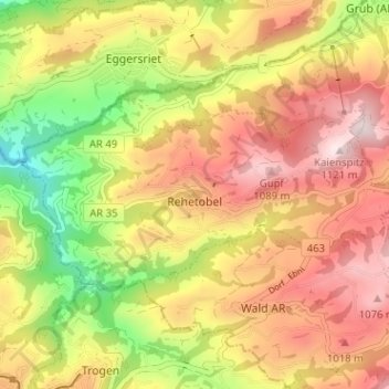
Name: Rehetobel topographic map, elevation, terrain.
Location: Rehetobel, Vorderland, Appenzell Ausserrhoden, 9038, Schweiz (47.41688 9.45192 47.43805 9.51548)
Average elevation: 2,907 ft
Minimum elevation: 2,028 ft
Maximum elevation: 3,645 ft
Make a donation
Gear up for your next adventure:
As an Amazon Associate, this site earns from qualifying purchases at no extra cost to you.