Geolocate

Marion topographic map

Click on the map to display elevation.

About this map

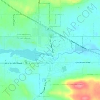
Name: Marion topographic map, elevation, terrain.

Location: Marion, Waupaca County, Wisconsin, United States (44.65974 -88.91032 44.69061 -88.86382)

Average elevation: 899 ft

Minimum elevation: 830 ft

Maximum elevation: 1,115 ft

Waupaca County trails, hiking, mountain biking, running and outdoor activities

Other topographic maps

Click on a map to view its topography, its elevation and its terrain.

King

United States > Wisconsin > Waupaca County

Average elevation: 912 ft

Readfield

United States > Wisconsin > Waupaca County

Average elevation: 827 ft

Holman Lake

United States > Wisconsin > Waupaca County

Average elevation: 925 ft

Gear up for your next adventure:

🧭Map Reading Tools - Tools and kits for map navigation
🗺️Topographic Maps - Detailed topo maps for hiking, exploring and outdoor navigation
🎒Waterproof Dry Bags - Keep your electronics and maps dry inside your pack
🎁Geography Themed Gifts - Unique gift ideas for map lovers and geography enthusiasts
🦟Ultrasonic Repellers - Create a bug-free zone at your camp or rest stop

As an Amazon Associate, this site earns from qualifying purchases at no extra cost to you.