
Make a donation
Gear up for your next adventure:
As an Amazon Associate, this site earns from qualifying purchases at no extra cost to you.
Olelas topographic map
Click on the map to display elevation.
Make a donation
Gear up for your next adventure:
As an Amazon Associate, this site earns from qualifying purchases at no extra cost to you.
About this map
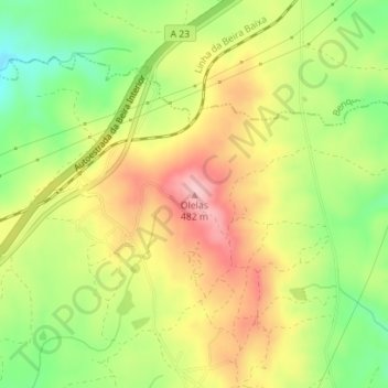
Name: Olelas topographic map, elevation, terrain.
Location: Olelas, Castelo Branco, 6000, Portugal (39.76812 -7.58089 39.76822 -7.58079)
Average elevation: 1,293 ft
Minimum elevation: 1,004 ft
Maximum elevation: 1,578 ft
Make a donation
Gear up for your next adventure:
As an Amazon Associate, this site earns from qualifying purchases at no extra cost to you.
Other topographic maps
Click on a map to view its topography, its elevation and its terrain.
Alcains
Portugal > Castelo Branco > Castelo Branco
Alcains encontra-se a 370 metros de altitude sendo atravessada pela Ribeira da Líria, afluente do Rio Ocreza que passa ainda dentro dos limites desta freguesia.
Average elevation: 1,188 ft
São Vicente da Beira
Portugal > Castelo Branco > Castelo Branco
A vila situa-se na Beira Baixa, no sopé da Serra da Gardunha, a uma altitude de 700 metros. Dista cerca de 30 km da sede município e capital de distrito, Castelo Branco.
Average elevation: 1,634 ft
Make a donation
Gear up for your next adventure:
As an Amazon Associate, this site earns from qualifying purchases at no extra cost to you.
Make a donation
Gear up for your next adventure:
As an Amazon Associate, this site earns from qualifying purchases at no extra cost to you.
Make a donation
Gear up for your next adventure:
As an Amazon Associate, this site earns from qualifying purchases at no extra cost to you.
Ninho do Açor
Portugal > Castelo Branco > Castelo Branco
Localizada na metade ocidental do concelho de Castelo Branco e de pequena extensăo - 1179,9 hectares -, Ninho de Açor vê-se confrontada a Norte e Poente pela vizinha Sobral do Campo, a Sul pela de Freixial do Campo e a Nascente por Tinalhas. Dista da sede concelhia cerca de 23Km. Com uma altitude próxima…
Average elevation: 1,250 ft
Alcains
Portugal > Castelo Branco > Castelo Branco
Alcains encontra-se a 370 metros de altitude sendo atravessada pela Ribeira da Líria, afluente do Rio Ocreza que passa ainda dentro dos limites desta freguesia.
Average elevation: 1,188 ft
Make a donation
Gear up for your next adventure:
As an Amazon Associate, this site earns from qualifying purchases at no extra cost to you.