
Make a donation
Gear up for your next adventure:
As an Amazon Associate, this site earns from qualifying purchases at no extra cost to you.
Kloten topographic map
Click on the map to display elevation.
Make a donation
Gear up for your next adventure:
As an Amazon Associate, this site earns from qualifying purchases at no extra cost to you.
Kloten
Kloten has an oceanic climate (Köppen Cfb), with sizeable continental influences due to its relative elevation and distance to any large bodies of water. Precipitation is high year-round and as a result of the cold winter nights, snowfall is frequent in winter. Due to the mild afternoons, this snow seldom sticks around for long periods of time. Summers are warm with frequent convective rainfall. The skies are generally gloomy, with a slight reversal of the trend during summer.
Make a donation
Gear up for your next adventure:
As an Amazon Associate, this site earns from qualifying purchases at no extra cost to you.
About this map
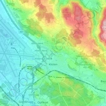
Name: Kloten topographic map, elevation, terrain.
Location: Kloten, Bezirk Bülach, Zurich, 8302, Switzerland (47.43581 8.54520 47.48131 8.63253)
Average elevation: 1,568 ft
Minimum elevation: 1,362 ft
Maximum elevation: 2,028 ft
Make a donation
Gear up for your next adventure:
As an Amazon Associate, this site earns from qualifying purchases at no extra cost to you.
Other topographic maps
Click on a map to view its topography, its elevation and its terrain.