
Make a donation
Gear up for your next adventure:
As an Amazon Associate, this site earns from qualifying purchases at no extra cost to you.
Schützingen topographic map
Click on the map to display elevation.
Make a donation
Gear up for your next adventure:
As an Amazon Associate, this site earns from qualifying purchases at no extra cost to you.
About this map
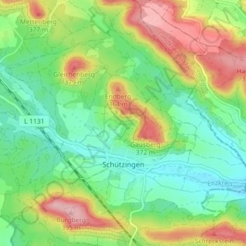
Name: Schützingen topographic map, elevation, terrain.
Location: Schützingen, Illingen, Enzkreis, Baden-Württemberg, Deutschland (48.98187 8.86926 49.02132 8.93302)
Average elevation: 978 ft
Minimum elevation: 784 ft
Maximum elevation: 1,299 ft
Make a donation
Gear up for your next adventure:
As an Amazon Associate, this site earns from qualifying purchases at no extra cost to you.
Other topographic maps
Click on a map to view its topography, its elevation and its terrain.
Mühlacker
Deutschland > Baden-Württemberg > Enzkreis > Mühlacker > Mühlacker
Das Gebiet von Mühlacker ist geprägt durch die Enz, einen linken Nebenfluss des Neckars. Die Enz erreicht von Südwesten kommend das Stadtgebiet bei Enzberg. Der Stadtteil Enzberg liegt links der Enz auf dem das Enztal begrenzenden Höhenzug. Nach Enzberg verläuft die Enz in einem weiten Rechtsbogen. In…
Average elevation: 922 ft
Make a donation
Gear up for your next adventure:
As an Amazon Associate, this site earns from qualifying purchases at no extra cost to you.