
Choczewo topographic map
Click on the map to display elevation.
About this map
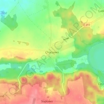
Name: Choczewo topographic map, elevation, terrain.
Average elevation: 220 ft
Minimum elevation: 105 ft
Maximum elevation: 341 ft
Other topographic maps
Click on a map to view its topography, its elevation and its terrain.
Wejherowo
Poland > Pomeranian Voivodeship > Wejherowo County
Wejherowo is located in Pomeralia, in the ethnocultural region of Kashubia, approximately 11 km (7 mi) west of the town of Rumia, 32 kilometres (20 miles) east of the town of Lębork and 35 km (22 mi) north-west of the regional metropole of Gdańsk, in the broad glacial valley of the river Rheda at an altitude…
Average elevation: 246 ft
Jezioro Żarnowieckie
Poland > Pomeranian Voivodeship > Wejherowo County > Czymanowo
Average elevation: 121 ft