Geolocate

Malla topographic map

Click on the map to display elevation.

About this map

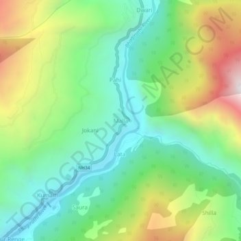
Name: Malla topographic map, elevation, terrain.

Location: Malla, Bhatwari, Uttarkashi, Uttarakhand, India (30.76644 78.59542 30.80644 78.63542)

Average elevation: 6,270 ft

Minimum elevation: 4,639 ft

Maximum elevation: 9,318 ft

Other topographic maps

Click on a map to view its topography, its elevation and its terrain.

Kyarkoti Lake

India > Uttarakhand > Bhatwari

Average elevation: 13,264 ft

Harsil

India > Uttarakhand > Bhatwari

Average elevation: 9,058 ft

Pari Maatri Taal

India > Uttarakhand > Bhatwari

Average elevation: 14,577 ft

Kedar Tal

India > Uttarakhand > Bhatwari

Average elevation: 15,794 ft

Pulam Sumda

India > Uttarakhand > Bhatwari

Average elevation: 14,997 ft

Dayara Bugyal

India > Uttarakhand > Bhatwari

Average elevation: 11,322 ft

Harsil

India > Uttarakhand > Bhatwari

Average elevation: 9,058 ft

Gangotri Glacier

India > Uttarakhand > Bhatwari

Average elevation: 17,254 ft

Kedar Tal

India > Uttarakhand > Bhatwari

Average elevation: 15,794 ft

Gangotri Glacier

India > Uttarakhand > Bhatwari

Average elevation: 17,254 ft

Kalindi Khal Area

India > Uttarakhand > Bhatwari

Average elevation: 19,216 ft

Gear up for your next adventure:

📌Outdoor GPS Map App - Apps and devices for digital topographic navigation
🌎3D Topographic Globes - Raised relief globes for a tactile understanding of geography
🧭Hiking Compass - Precision compass for reliable navigation in the wilderness
🪑Portable Camp Table - Compact table for campsite meals
🧴Hand Sanitizer - Keep hands clean while hiking

As an Amazon Associate, this site earns from qualifying purchases at no extra cost to you.