Geolocate

Bogota topographic map

Click on the map to display elevation.

About this map

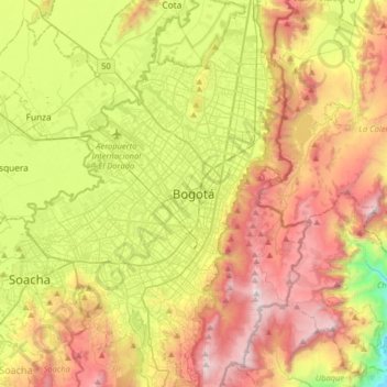
Name: Bogota topographic map, elevation, terrain.

Location: Bogota, Distrito Capital de Bogotá, 110321, Colombia (4.43808 -74.23604 4.75808 -73.91604)

Average elevation: 9,075 ft

Minimum elevation: 5,436 ft

Maximum elevation: 12,126 ft

Gear up for your next adventure:

🧭GPS Watch Accessories - Bands and chargers for GPS watches
🎁Geography Themed Gifts - Unique gift ideas for map lovers and geography enthusiasts
🔋Rechargeable Batteries - Power up your outdoor devices
🪶Thermal Camp Blanket - Extra warmth for cold nights
🧢Sun Protection Hats - Wide-brimmed and UPF-rated hats for high-altitude sun safety

As an Amazon Associate, this site earns from qualifying purchases at no extra cost to you.