Geolocate

Bethersden topographic map

Click on the map to display elevation.

About this map

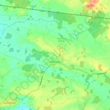
Name: Bethersden topographic map, elevation, terrain.

Location: Bethersden, Ashford, Kent, England, United Kingdom (51.10660 0.70722 51.15573 0.80834)

Average elevation: 125 ft

Minimum elevation: 59 ft

Maximum elevation: 236 ft

Other topographic maps

Click on a map to view its topography, its elevation and its terrain.

Hamstreet

United Kingdom > England > Kent > Ashford

Average elevation: 72 ft

Hinxhill

United Kingdom > England > Kent > Ashford

Average elevation: 167 ft

Gear up for your next adventure:

🦶Carbon Trekking Poles - Reduce knee impact on steep descents with ultra-light poles
🪄Magnetic Compass - Accurate compass for navigation
Backpacking Tents - Weight-optimized shelters for multi-day topographic surveys
🧦Hiking Socks - Comfortable socks to prevent blisters on long hikes
📖Nature Tracking Books - Learn to track wildlife and terrain

As an Amazon Associate, this site earns from qualifying purchases at no extra cost to you.