
Žabljak Municipality topographic map
Interactive map
Click on the map to display elevation.
About this map
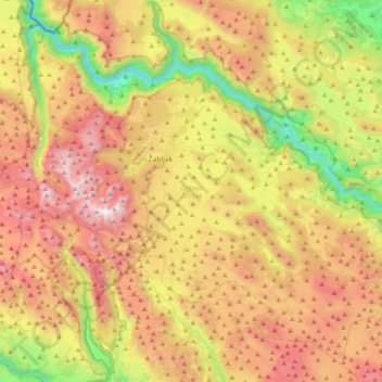
Name: Žabljak Municipality topographic map, elevation, terrain.
Location: Žabljak Municipality, 84220, Montenegro (42.99675 18.97187 43.26254 19.37208)
Average elevation: 4,777 ft
Minimum elevation: 1,798 ft
Maximum elevation: 8,077 ft
Other topographic maps
Click on a map to view its topography, its elevation and its terrain.
Žabljak
Montenegro > Žabljak Municipality
Žabljak is the seat of Žabljak Municipality (2011 population: 3,569). The town is in the centre of the Durmitor mountain region and with an altitude of 1,456 metres, it is the highest situated Balkan town.
Average elevation: 4,793 ft
Šavnik
Montenegro > Šavnik Municipality
Šavnik (Cyrillic: Шавник, pronounced [ʃǎv̞niːk]) is a town in Montenegro in the northern region and administrative center of the Šavnik Municipality. It is located at the confluence of three rivers - Bukovica, Bijela and Šavnik, at an altitude of 840 meters. It is the lowest lying settlement in…
Average elevation: 3,350 ft
Pljevlja
Montenegro > Pljevlja Municipality
The town lies at an altitude of 770 m (2,530 ft). In the Middle Ages, Pljevlja had been a crossroad of the important commercial roads and cultural streams, with important roads connecting the littoral with the Balkan interior. In 2023, the municipality of Pljevlja had a population of 24,542, while the city…
Average elevation: 2,772 ft
Mojkovac
Montenegro > Mojkovac Municipality
The municipality of Mojkovac covers an area of 367 km2 (142 sq mi) and according to the number of inhabitants (10 015 / 2003g) belongs among the smaller municipalities in Montenegro. The city resort is located at an altitude of 853 m (2,799 ft). Its mathematical position is determined by geographical…
Average elevation: 2,946 ft
Kolašin
Montenegro > Kolašin Municipality > Kolašin
Kolašin is located on the foot of Bjelasica and Sinjajevina mountains, which offer great conditions for skiing. Because of Kolašin's altitude (954 m), the town is considered an air spa.
Average elevation: 3,717 ft
Gusinje
Montenegro > Gusinje Municipality
The town is located in the Plav-Gusinje area, part of the upper Lim valley in the Accursed Mountains range at an elevation of 1,014 m. Zla Kolata, the highest mountain in Montenegro about 10 km south of Gusinje in the Prokletije National Park.
Average elevation: 4,249 ft
Mojkovac
Montenegro > Mojkovac Municipality
The municipality of Mojkovac covers an area of 367 km2 (142 sq mi) and according to the number of inhabitants (10 015 / 2003g) belongs among the smaller municipalities in Montenegro. The city resort is located at an altitude of 853 m (2,799 ft). Its mathematical position is determined by geographical…
Average elevation: 2,946 ft
Žabljak
Montenegro > Žabljak Municipality
Žabljak is the seat of Žabljak Municipality (2011 population: 3,569). The town is in the centre of the Durmitor mountain region and with an altitude of 1,456 metres, it is the highest situated Balkan town.
Average elevation: 4,793 ft
Pljevlja
Montenegro > Pljevlja Municipality
The town lies at an altitude of 770 m (2,530 ft). In the Middle Ages, Pljevlja had been a crossroad of the important commercial roads and cultural streams, with important roads connecting the littoral with the Balkan interior. In 2023, the municipality of Pljevlja had a population of 24,542, while the city…
Average elevation: 2,772 ft
Žijeva glava / Maja e Zhihovës (B6/XXIV)
Montenegro > Andrijevica Municipality
Average elevation: 6,050 ft
Gusinje
Montenegro > Gusinje Municipality
The town is located in the Plav-Gusinje area, part of the upper Lim valley in the Accursed Mountains range at an elevation of 1,014 m. Zla Kolata, the highest mountain in Montenegro about 10 km south of Gusinje in the Prokletije National Park.
Average elevation: 4,249 ft
View over the sea, mountain, and Buljarica beach
Montenegro > Budva Municipality > Buljarica > Bačvice
Average elevation: 95 ft
Kolašin
Montenegro > Kolašin Municipality > Kolašin
Kolašin is located on the foot of Bjelasica and Sinjajevina mountains, which offer great conditions for skiing. Because of Kolašin's altitude (954 m), the town is considered an air spa.
Average elevation: 3,717 ft
Accursed Mountains
Montenegro > Gusinje Municipality
The Accursed Mountains are a typical Dinaric karst high mountain range with a pronounced steep topography and glacial features. Maximum relief differences of 1,800 metres (5,900 ft) are found in the Valbona, Grbaja and Ropojani and Cem valleys. Overhanging walls and ridges forming pointed peaks are typical of…
Average elevation: 5,499 ft