Geolocate

Bagtas topographic map

Click on the map to display elevation.

About this map

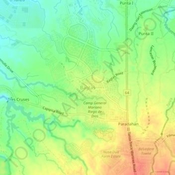
Name: Bagtas topographic map, elevation, terrain.

Location: Bagtas, Tanza, Cavite, Calabarzon, 4108, Philippines (14.31287 120.83067 14.35287 120.87067)

Average elevation: 141 ft

Minimum elevation: 62 ft

Maximum elevation: 230 ft

Other topographic maps

Click on a map to view its topography, its elevation and its terrain.

Matanda Dam

Philippines > Cavite > Tanza

Average elevation: 190 ft

Gear up for your next adventure:

🪑Ultralight Camp Chairs - Portable seating for resting after a long day of mapping
🔥Camping Stove - Portable stove for camping and backcountry cooking
🏫Relief Map Kits - Hands-on tools for teaching landforms and elevation
🪶Thermal Camp Blanket - Extra warmth for cold nights
🎁Geography Themed Gifts - Unique gift ideas for map lovers and geography enthusiasts

As an Amazon Associate, this site earns from qualifying purchases at no extra cost to you.