
Kariba topographic map
Click on the map to display elevation.
Kariba
Kariba has a tropical savanna climate (Köppen climate classification Aw), with warm winters and very hot summers, and a marked drier season in the winter. Although it is relatively cooler than typical tropical places in the winter and does get occasional 5 °C (41 °F) lows, Kariba nevertheless meets the minimum requirements to be in the savanna climate zone, making it one of few locations in Zimbabwe within this classification. The city's low elevation by Zimbabwean standards, lakeside location, northern locality, and proximity to the Intertropical Convergence Zone shape its climate. Average winter high temperatures, from May to August, range from 24.7 to 26.8 °C (76.4 to 80.3 °F). July is the coolest month with an average daily temperature of 20.1 °C (68.2 °F). Low temperatures fall below 10 °C (50 °F) about 10–15 nights during the winter season, after the passage of cold fronts from the south east that may sometimes produce winter precipitation.
About this map
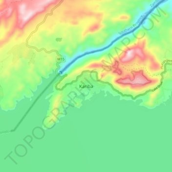
Name: Kariba topographic map, elevation, terrain.
Location: Kariba, Mashonaland West Province, Zimbabwe (-16.56727 28.73555 -16.48727 28.81555)
Average elevation: 1,804 ft
Minimum elevation: 1,253 ft
Maximum elevation: 2,881 ft