
Thank you for supporting this site ❤️
Make a donation
Make a donation
Gear up for your next adventure:
As an Amazon Associate, this site earns from qualifying purchases at no extra cost to you.
Chachapoyas topographic map
Click on the map to display elevation.
Thank you for supporting this site ❤️
Make a donation
Make a donation
Gear up for your next adventure:
As an Amazon Associate, this site earns from qualifying purchases at no extra cost to you.
Chachapoyas
Esta ciudad se ubica a una altitud de 2.483 m s. n. m., en el nor-oriente peruano, cerca al río Utcubamba.
Thank you for supporting this site ❤️
Make a donation
Make a donation
Gear up for your next adventure:
As an Amazon Associate, this site earns from qualifying purchases at no extra cost to you.
About this map
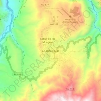
Name: Chachapoyas topographic map, elevation, terrain.
Location: Chachapoyas, Amazonas, 01001, Perú (-6.26932 -77.91146 -6.18932 -77.83146)
Average elevation: 7,480 ft
Minimum elevation: 5,361 ft
Maximum elevation: 10,046 ft
Thank you for supporting this site ❤️
Make a donation
Make a donation
Gear up for your next adventure:
As an Amazon Associate, this site earns from qualifying purchases at no extra cost to you.