Geolocate

Retamar topographic map

Click on the map to display elevation.

About this map

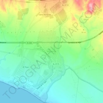
Name: Retamar topographic map, elevation, terrain.

Location: Retamar, Almeria, Andalusia, 04131, Spain (36.82863 -2.32616 36.86863 -2.28616)

Average elevation: 164 ft

Minimum elevation: -7 ft

Maximum elevation: 482 ft

Gear up for your next adventure:

🔥Camping Stove - Portable stove for camping and backcountry cooking
🖼️Topo Map Wall Art - Decorative topographic prints of famous peaks and regions
📱Solar Portable Charger - Solar power bank for charging devices off‑grid
🧤Hiking Gloves - Protective gloves for rugged trails
🎒Outdoor Daypacks - Lightweight backpacks designed for carrying maps and essential gear

As an Amazon Associate, this site earns from qualifying purchases at no extra cost to you.