
Make a donation
Gear up for your next adventure:
As an Amazon Associate, this site earns from qualifying purchases at no extra cost to you.
Yilan County topographic map
Click on the map to display elevation.
Make a donation
Gear up for your next adventure:
As an Amazon Associate, this site earns from qualifying purchases at no extra cost to you.
Yilan County
Yilan County is located in the northeastern Taiwan Island which covers an area of 2,143 km2. The longest distance from east to west is 63 km and from north to south is 74 km. From the mountain areas downwards, the land falls in altitude in the stages of mountains, alleys, alluvial plains, lowlands, swamps, sand hills and finally coastline.
Make a donation
Gear up for your next adventure:
As an Amazon Associate, this site earns from qualifying purchases at no extra cost to you.
About this map
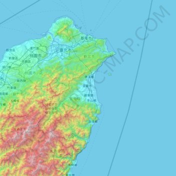
Name: Yilan County topographic map, elevation, terrain.
Location: Yilan County, 26060, Taiwan (24.03028 121.06311 25.43028 122.46311)
Average elevation: 1,365 ft
Minimum elevation: -7 ft
Maximum elevation: 12,592 ft
Make a donation
Gear up for your next adventure:
As an Amazon Associate, this site earns from qualifying purchases at no extra cost to you.