Geolocate

Pralungo topographic map

Click on the map to display elevation.

About this map

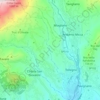
Name: Pralungo topographic map, elevation, terrain.

Location: Pralungo, Biella, Piedmont, 13899, Italy (45.57924 7.99808 45.62508 8.05068)

Average elevation: 2,077 ft

Minimum elevation: 1,368 ft

Maximum elevation: 4,462 ft

Other topographic maps

Click on a map to view its topography, its elevation and its terrain.

Ravizza

Italy > Piedmont > Biella > Andorno Micca

Average elevation: 2,241 ft

Gear up for your next adventure:

🎒Waterproof Dry Bags - Keep your electronics and maps dry inside your pack
🪵Folding Camp Saw - Compact saw for wood and campsite work
🧷Carabiner Set - Durable clips for gear attachment
🏥Hiking First Aid Kits - Comprehensive medical kits for remote trail injuries
Backpacking Tent - Lightweight and durable tent for multi‑day hikes

As an Amazon Associate, this site earns from qualifying purchases at no extra cost to you.