
Make a donation
Gear up for your next adventure:
As an Amazon Associate, this site earns from qualifying purchases at no extra cost to you.
Mount Rushmore National Memorial topographic map
Click on the map to display elevation.
Make a donation
Gear up for your next adventure:
As an Amazon Associate, this site earns from qualifying purchases at no extra cost to you.
Mount Rushmore National Memorial
The Mount Rushmore National Memorial is a national memorial centered on a colossal sculpture carved into the granite face of Mount Rushmore (Lakota: Tȟuŋkášila Šákpe, or Six Grandfathers) in the Black Hills near Keystone, South Dakota, United States. Sculptor Gutzon Borglum designed the sculpture, called Shrine of Democracy, and oversaw the project's execution from 1927 to 1941 with the help of his son, Lincoln Borglum. The sculpture features the 60-foot-tall (18 m) heads of four United States presidents: George Washington, Thomas Jefferson, Theodore Roosevelt, and Abraham Lincoln, chosen to represent the nation's birth, growth, development and preservation, respectively. Mount Rushmore attracts more than two million visitors annually to the memorial park which covers 1,278 acres (2.00 sq mi; 5.17 km2). The mountain's elevation is 5,725 feet (1,745 m) above sea level.
Make a donation
Gear up for your next adventure:
As an Amazon Associate, this site earns from qualifying purchases at no extra cost to you.
About this map
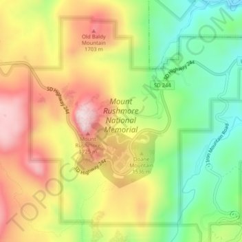
Name: Mount Rushmore National Memorial topographic map, elevation, terrain.
Average elevation: 5,013 ft
Minimum elevation: 4,406 ft
Maximum elevation: 5,663 ft
Pennington County trails, hiking, mountain biking, running and outdoor activities
Make a donation
Gear up for your next adventure:
As an Amazon Associate, this site earns from qualifying purchases at no extra cost to you.
Other topographic maps
Click on a map to view its topography, its elevation and its terrain.
Black Hills
United States > South Dakota > Pennington County
The Black Hills is an isolated mountain range rising from the Great Plains of North America in western South Dakota and extending into Wyoming, United States. Black Elk Peak, which rises to 7,242 feet (2,207 m), is the range's highest summit. The name of the range in Lakota is Pahá Sápa. It encompasses the…
Average elevation: 6,214 ft
Make a donation
Gear up for your next adventure:
As an Amazon Associate, this site earns from qualifying purchases at no extra cost to you.
Pactola Reservoir Recreation Area
United States > South Dakota > Pennington County
Average elevation: 4,892 ft
Black Elk Peak
United States > South Dakota > Pennington County
In September 2016, a team of professional surveyors obtained precise GNSS data over the course of two days and found the highest natural rock to be at 7,231.32 feet (2,204.11 m) NAVD88 and a nearby secondary peak located approximately 300 feet south of the lookout tower and unofficially named "McGillicuddy's…
Average elevation: 6,309 ft
Make a donation
Gear up for your next adventure:
As an Amazon Associate, this site earns from qualifying purchases at no extra cost to you.
Mount Rushmore
United States > South Dakota > Pennington County
Mount Rushmore National Memorial is centered on a colossal sculpture carved into the granite face of Mount Rushmore (Lakota: Tȟuŋkášila Šákpe, or Six Grandfathers) in the Black Hills near Keystone, South Dakota. Sculptor Gutzon Borglum created the sculpture's design and oversaw the project's execution…
Average elevation: 5,125 ft
Black Hills
United States > South Dakota > Pennington County
The Black Hills is an isolated mountain range rising from the Great Plains of North America in western South Dakota and extending into Wyoming, United States. Black Elk Peak, which rises to 7,242 feet (2,207 m), is the range's highest summit. The name of the range in Lakota is Pahá Sápa. It encompasses the…
Average elevation: 6,214 ft
Make a donation
Gear up for your next adventure:
As an Amazon Associate, this site earns from qualifying purchases at no extra cost to you.
Sage Creek Basin Overlook
United States > South Dakota > Pennington County
Average elevation: 2,851 ft