
Silver City topographic map
Click on the map to display elevation.
About this map
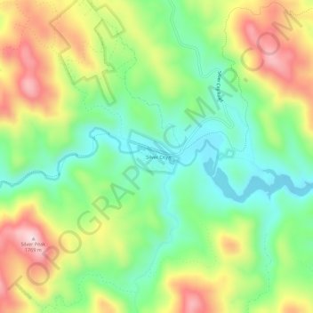
Name: Silver City topographic map, elevation, terrain.
Average elevation: 5,036 ft
Minimum elevation: 4,547 ft
Maximum elevation: 5,751 ft
Pennington County trails, hiking, mountain biking, running and outdoor activities
Other topographic maps
Click on a map to view its topography, its elevation and its terrain.
Rapid City
United States > South Dakota > Pennington County
Rapid City is located at 44°04′34″N 103°13′42″W / 44.076188°N 103.228299°W / 44.076188; -103.228299. The downtown elevation of Rapid City is 3,202 feet (976 m). Rapid City is located in the shadow of Black Elk Peak, which at 7,242 feet (2,207 m), is the highest point east of the Rocky Mountains.
Average elevation: 3,501 ft
Rapid City
United States > South Dakota > Pennington County
Rapid City is located at 44°04′34″N 103°13′42″W / 44.076188°N 103.228299°W / 44.076188; -103.228299. The downtown elevation of Rapid City is 3,202 feet (976 m). Rapid City is located in the shadow of Black Elk Peak, which at 7,242 feet (2,207 m), is the highest point east of the Rocky Mountains.
Average elevation: 3,504 ft
Mount Rushmore National Memorial
United States > South Dakota > Pennington County
The Mount Rushmore National Memorial is a national memorial centered on a colossal sculpture carved into the granite face of Mount Rushmore (Lakota: Tȟuŋkášila Šákpe, or Six Grandfathers) in the Black Hills near Keystone, South Dakota, United States. Sculptor Gutzon Borglum designed the sculpture, called…
Average elevation: 5,013 ft
Johnson Siding
United States > South Dakota > Pennington County > Johnson Siding
Average elevation: 4,619 ft
Mount Rushmore National Memorial
United States > South Dakota > Pennington County
The Mount Rushmore National Memorial is a national memorial centered on a colossal sculpture carved into the granite face of Mount Rushmore (Lakota: Tȟuŋkášila Šákpe, or Six Grandfathers) in the Black Hills near Keystone, South Dakota, United States. The sculptor, Gutzon Borglum, named it the Shrine of…
Average elevation: 5,013 ft
Rapid City
United States > South Dakota > Pennington County
Rapid City is located at 44°04′34″N 103°13′42″W / 44.076188°N 103.228299°W / 44.076188; -103.228299. The downtown elevation of Rapid City is 3,202 feet (976 m). Rapid City is located in the shadow of Black Elk Peak, which at 7,242 feet (2,207 m), is the highest point east of the Rocky Mountains.
Average elevation: 3,504 ft
Mount Rushmore National Memorial
United States > South Dakota > Pennington County
Mount Rushmore National Memorial is a national memorial centered on a colossal sculpture carved into the granite face of Mount Rushmore (Lakota: Tȟuŋkášila Šákpe, or Six Grandfathers) in the Black Hills near Keystone, South Dakota, United States. Sculptor Gutzon Borglum created the sculpture's design and…
Average elevation: 5,013 ft
Rapid Valley
United States > South Dakota > Pennington County > Rapid Valley
Average elevation: 3,205 ft