Geolocate

Pfullingen topographic map

Click on the map to display elevation.

About this map

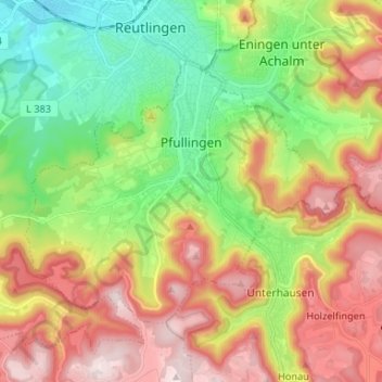
Name: Pfullingen topographic map, elevation, terrain.

Location: Pfullingen, Landkreis Reutlingen, Baden-Württemberg, 72793, Germany (48.42421 9.16802 48.48449 9.29982)

Average elevation: 1,854 ft

Minimum elevation: 1,142 ft

Maximum elevation: 2,756 ft

Other topographic maps

Click on a map to view its topography, its elevation and its terrain.

Honau

Germany > Baden-Württemberg > Landkreis Reutlingen > Honau

Average elevation: 2,323 ft

Engstingen

Germany > Baden-Württemberg > Landkreis Reutlingen

Engstingen is located on the northern edge of the Swabian Jura, at 680–750 metres (2,230–2,460 ft) altitude on the Alb plateau near the Alb edge in the valley of Ur-Lauter, about 15 km south of the town Reutlingen.

Average elevation: 2,421 ft

Gear up for your next adventure:

🔌Solar Panel Charger - Charge gear sustainably outdoors
Backpacking Tents - Weight-optimized shelters for multi-day topographic surveys
🚁Photography Drones - Capture stunning aerial views of landforms and topography
📱Heavy-Duty Phone Cases - Drop-proof and waterproof protection for outdoor navigation
🔊Portable Camp Speaker - Music and alerts at camp

As an Amazon Associate, this site earns from qualifying purchases at no extra cost to you.