
Bedford topographic map
Click on the map to display elevation.
About this map
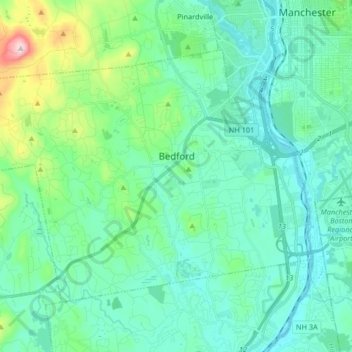
Name: Bedford topographic map, elevation, terrain.
Average elevation: 318 ft
Minimum elevation: 95 ft
Maximum elevation: 1,319 ft
Hillsborough County trails, hiking, mountain biking, running and outdoor activities
Other topographic maps
Click on a map to view its topography, its elevation and its terrain.
Souhegan River
United States > New Hampshire > Hillsborough County > Milford > East Milford
Average elevation: 276 ft
Joe English Hill
United States > New Hampshire > Hillsborough County > New Boston
Average elevation: 810 ft
Souhegan River Watershed Dam Number 35
United States > New Hampshire > Hillsborough County > New Ipswich > Smithville
Average elevation: 1,145 ft
Piscataquog River
United States > New Hampshire > Hillsborough County > Manchester
Average elevation: 194 ft
South Uncanoonuc Mountain
United States > New Hampshire > Hillsborough County > Goffstown
Average elevation: 797 ft
New Ipswich Center
United States > New Hampshire > Hillsborough County > New Ipswich
Average elevation: 1,063 ft
Souhegan River
United States > New Hampshire > Hillsborough County > Milford > East Milford
Average elevation: 276 ft
West Peterborough
United States > New Hampshire > Hillsborough County > Peterborough
Average elevation: 981 ft
Hillsboro Lower Village
United States > New Hampshire > Hillsborough County > Hillsborough
Average elevation: 794 ft
Campbell Mountain
United States > New Hampshire > Hillsborough County > Hillsborough
Average elevation: 1,109 ft
South Weare
United States > New Hampshire > Hillsborough County > Weare > South Weare
Average elevation: 689 ft
North Brookline
United States > New Hampshire > Hillsborough County > Brookline > North Brookline
Average elevation: 407 ft
Nakuru Lake
United States > New Hampshire > Hillsborough County > Hudson > Hudson Center
Average elevation: 262 ft
Massachusetts Drive Park
United States > New Hampshire > Hillsborough County > Nashua
Average elevation: 157 ft