Geolocate

Hideout topographic map

Click on the map to display elevation.

About this map

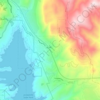
Name: Hideout topographic map, elevation, terrain.

Location: Hideout, Wasatch County, Utah, United States (40.62422 -111.42647 40.66967 -111.37668)

Average elevation: 6,781 ft

Minimum elevation: 6,132 ft

Maximum elevation: 7,940 ft

Wasatch County trails, hiking, mountain biking, running and outdoor activities

Other topographic maps

Click on a map to view its topography, its elevation and its terrain.

Soldier Summit

United States > Utah > Wasatch County

Average elevation: 7,621 ft

Midway City Hamlet Park

United States > Utah > Wasatch County > Midway

Average elevation: 5,545 ft

Gear up for your next adventure:

🗃️Trail First Aid Kit - Essential kit for outdoor injuries and emergencies
🏔️Mountain Trail Maps - High‑detail maps for popular peaks
GPS Sports Watch - GPS watch for running, hiking and training
👟Men's Trail Runners - Lightweight footwear for fast-paced exploration and light hiking
🎒Hydration Pack - Hands‑free water reservoir for long hikes

As an Amazon Associate, this site earns from qualifying purchases at no extra cost to you.