
Thank you for supporting this site ❤️
Make a donation
Make a donation
Gear up for your next adventure:
As an Amazon Associate, this site earns from qualifying purchases at no extra cost to you.
Amsterdam topographic map
Click on the map to display elevation.
Thank you for supporting this site ❤️
Make a donation
Make a donation
Gear up for your next adventure:
As an Amazon Associate, this site earns from qualifying purchases at no extra cost to you.
About this map
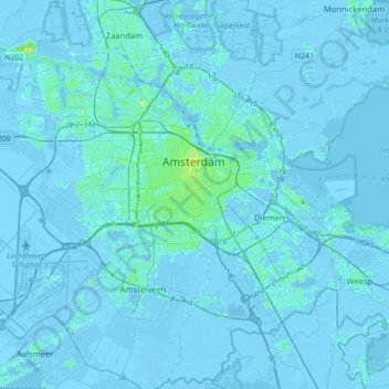
Name: Amsterdam topographic map, elevation, terrain.
Location: Amsterdam, Hollande-Septentrionale, Pays-Bas (52.27817 4.72876 52.43106 5.07916)
Average elevation: 0 ft
Minimum elevation: -26 ft
Maximum elevation: 59 ft
Thank you for supporting this site ❤️
Make a donation
Make a donation
Gear up for your next adventure:
As an Amazon Associate, this site earns from qualifying purchases at no extra cost to you.
Other topographic maps
Click on a map to view its topography, its elevation and its terrain.
Zeeburgereiland
Pays-Bas > Hollande-Septentrionale > Amsterdam > Schellingwoude
Average elevation: 3 ft