
Make a donation
Gear up for your next adventure:
As an Amazon Associate, this site earns from qualifying purchases at no extra cost to you.
Waterford Township topographic map
Click on the map to display elevation.
Make a donation
Gear up for your next adventure:
As an Amazon Associate, this site earns from qualifying purchases at no extra cost to you.
Waterford Township
Like the rest of Southeast Michigan, Waterford Township has a continental climate. It has a higher elevation than Detroit (982 feet (299 m) compared to 585 feet (178 m)), and therefore the township is somewhat cooler than Detroit and other nearby cities. It is moderately cold in the winter with varied snowfall throughout. Spring varies from warm by day to cool at night. The township's warmest weather occurs in the summer with temperatures in the eighty to ninety degree range and typically high humidity. Summer is also the wettest season in the area. In recent years, Waterford Township has seen a few 100-plus degree days. Fall starts warm, but November ends with high temperatures barely above freezing.
Make a donation
Gear up for your next adventure:
As an Amazon Associate, this site earns from qualifying purchases at no extra cost to you.
About this map
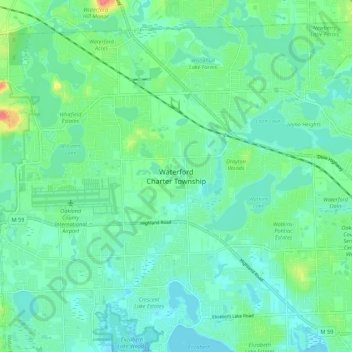
Name: Waterford Township topographic map, elevation, terrain.
Average elevation: 968 ft
Minimum elevation: 919 ft
Maximum elevation: 1,122 ft
Make a donation
Gear up for your next adventure:
As an Amazon Associate, this site earns from qualifying purchases at no extra cost to you.