Germantown topographic map
Interactive map
Click on the map to display elevation.
About this map
![Germantown topographic map, elevation, terrain](/pub/maps/relation/3g14/wcrtf/thumbnail.jpg)
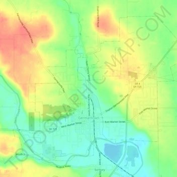
Name: Germantown topographic map, elevation, terrain.
Location: Germantown, Montgomery County, Ohio, 45327, United States (39.61531 -84.39413 39.65174 -84.33630)
Average elevation: 781 ft
Minimum elevation: 682 ft
Maximum elevation: 896 ft
Other topographic maps
Click on a map to view its topography, its elevation and its terrain.
![Dayton topographic map, elevation, terrain](/pub/maps/relation/dq4s/m6751/icon.jpg)
Dayton
United States > Ohio > Montgomery County
Dayton, Montgomery County, Ohio, United States
Average elevation: 886 ft
![Little York topographic map, elevation, terrain](/pub/maps/node/xpt6/46tbgm2/icon.jpg)
Little York
United States > Ohio > Montgomery County
Little York, Montgomery County, Ohio, 45415, United States
Average elevation: 883 ft
![Boone Island (historical) topographic map, elevation, terrain](/pub/maps/node/x1zs/72kvg6zs/icon.jpg)
Boone Island (historical)
United States > Ohio > Montgomery County > West Carrollton
Boone Island (historical), West Carrollton, Montgomery County, Ohio, 45449, United States
Average elevation: 906 ft
![Kettering topographic map, elevation, terrain](/pub/maps/relation/hwmt/t3dcz/icon.jpg)
Kettering
United States > Ohio > Montgomery County
Kettering, Montgomery County, Ohio, United States
Average elevation: 902 ft
![Shiloh topographic map, elevation, terrain](/pub/maps/relation/85z4/l9bgp/icon.jpg)
Shiloh
United States > Ohio > Montgomery County > Shiloh
Shiloh, Montgomery County, Ohio, United States
Average elevation: 860 ft
![Clement topographic map, elevation, terrain](/pub/maps/node/lhtp/b1xs9t6/icon.jpg)
Clement
United States > Ohio > Montgomery County > Riverside
Clement, Riverside, Montgomery County, Ohio, 45432, United States
Average elevation: 902 ft
![Miamisburg Community Park topographic map, elevation, terrain](/pub/maps/way/d61h/lcj2w51/icon.jpg)
Miamisburg Community Park
United States > Ohio > Montgomery County > Miamisburg
Miamisburg Community Park, Miamisburg, Miami Township, Montgomery County, Ohio, United States
Average elevation: 791 ft
![Berkley Heights topographic map, elevation, terrain](/pub/maps/node/wq57/dgb76z4/icon.jpg)
Berkley Heights
United States > Ohio > Montgomery County > Kettering
Berkley Heights, Kettering, Montgomery County, Ohio, 45439, United States
Average elevation: 830 ft
![Miamisburg topographic map, elevation, terrain](/pub/maps/relation/t651/dgbz4/icon.jpg)
Miamisburg
United States > Ohio > Montgomery County
Miamisburg, Montgomery County, Ohio, 45342, United States
Average elevation: 810 ft
![Dayton topographic map, elevation, terrain](/pub/maps/node/ml1h/kqk8bf3/icon.jpg)
Dayton
United States > Ohio > Montgomery County > Dayton
Dayton, Montgomery County, Ohio, 45423, United States
Average elevation: 886 ft
![Clayton topographic map, elevation, terrain](/pub/maps/relation/8wnh/dgb14/icon.jpg)
Clayton
United States > Ohio > Montgomery County
Clayton, Montgomery County, Ohio, 45315, United States
Average elevation: 984 ft
![Patterson topographic map, elevation, terrain](/pub/maps/node/vqrr/jvhbw5k/icon.jpg)
Patterson
United States > Ohio > Montgomery County > Dayton
Patterson, Dayton, Montgomery County, Ohio, 45408, United States
Average elevation: 764 ft
![West Carrollton topographic map, elevation, terrain](/pub/maps/relation/49gt/n3s3q/icon.jpg)
West Carrollton
United States > Ohio > Montgomery County
West Carrollton, Montgomery County, Ohio, 45449, United States
Average elevation: 781 ft
![Farmersville topographic map, elevation, terrain](/pub/maps/relation/8w1h/75j18/icon.jpg)
Farmersville
United States > Ohio > Montgomery County
Farmersville, Montgomery County, Ohio, 45325, United States
Average elevation: 850 ft
![Washington Township topographic map, elevation, terrain](/pub/maps/relation/3751/jt74nh/icon.jpg)
Washington Township
United States > Ohio > Montgomery County
Washington Township, Montgomery County, Ohio, United States
Average elevation: 935 ft
![Oakwood topographic map, elevation, terrain](/pub/maps/relation/dc3l/fxb1h/icon.jpg)
Oakwood
United States > Ohio > Montgomery County
Oakwood, Montgomery County, Ohio, 45419, United States
Average elevation: 919 ft
![Residence Park topographic map, elevation, terrain](/pub/maps/node/8ptp/xz1kxkl/icon.jpg)
Residence Park
United States > Ohio > Montgomery County > Dayton
Residence Park, Dayton, Montgomery County, Ohio, 45428, United States
Average elevation: 873 ft
![West Side topographic map, elevation, terrain](/pub/maps/node/6pgt/3kc4jdn/icon.jpg)
West Side
United States > Ohio > Montgomery County > Dayton
West Side, Dayton, Montgomery County, Ohio, 45407, United States
Average elevation: 761 ft
![Riverside topographic map, elevation, terrain](/pub/maps/relation/3gz4/lxwgp/icon.jpg)
Riverside
United States > Ohio > Montgomery County
Riverside, Montgomery County, Ohio, 45437, United States
Average elevation: 840 ft
![Trotwood topographic map, elevation, terrain](/pub/maps/relation/92t6/9qzzs/icon.jpg)
Trotwood
United States > Ohio > Montgomery County
Trotwood, Montgomery County, Ohio, United States
Average elevation: 902 ft
![Englewood topographic map, elevation, terrain](/pub/maps/relation/cl3q/37wdn/icon.jpg)
Englewood
United States > Ohio > Montgomery County
Englewood, Montgomery County, Ohio, 45322, United States
Average elevation: 925 ft
![Greenmont topographic map, elevation, terrain](/pub/maps/node/79z4/51v9157/icon.jpg)
Greenmont
United States > Ohio > Montgomery County > Kettering
Greenmont, Kettering, Montgomery County, Ohio, 45420, United States
Average elevation: 925 ft
![Pasadena topographic map, elevation, terrain](/pub/maps/node/vs51/fw2hfnh/icon.jpg)
Pasadena
United States > Ohio > Montgomery County > Kettering
Pasadena, Kettering, Montgomery County, Ohio, 45429, United States
Average elevation: 981 ft
![Miami Township topographic map, elevation, terrain](/pub/maps/relation/12m2/b1bbgt/icon.jpg)
Miami Township
United States > Ohio > Montgomery County
Miami Township, Montgomery County, Ohio, United States
Average elevation: 892 ft
![Centerville topographic map, elevation, terrain](/pub/maps/node/5ckl/v89p4tj/icon.jpg)
Centerville
United States > Ohio > Montgomery County > Centerville > Centerville
Centerville, Montgomery County, Ohio, 45459, United States
Average elevation: 945 ft
![Miami Shores topographic map, elevation, terrain](/pub/maps/node/kq14/9zsfszs/icon.jpg)
Miami Shores
United States > Ohio > Montgomery County > Moraine
Miami Shores, Moraine, Montgomery County, Ohio, 45439, United States
Average elevation: 761 ft
![Miamisburg topographic map, elevation, terrain](/pub/maps/node/pk51/fw28xnh/icon.jpg)
Miamisburg
United States > Ohio > Montgomery County > Miamisburg > Miamisburg
Miamisburg, Montgomery County, Ohio, 45342, United States
Average elevation: 804 ft
![Crown Point topographic map, elevation, terrain](/pub/maps/node/k6z4/51d7b57/icon.jpg)
Crown Point
United States > Ohio > Montgomery County > Dayton > Crown Point
Crown Point, Dayton, Montgomery County, Ohio, 45428, United States
Average elevation: 896 ft
![New Lebanon topographic map, elevation, terrain](/pub/maps/relation/l518/b21t6/icon.jpg)
New Lebanon
United States > Ohio > Montgomery County > New Lebanon
New Lebanon, Montgomery County, Ohio, United States
Average elevation: 912 ft
![Oakdale topographic map, elevation, terrain](/pub/maps/node/q65k/ts96pcz/icon.jpg)
Oakdale
United States > Ohio > Montgomery County > Kettering
Oakdale, Kettering, Montgomery County, Ohio, 45429, United States
Average elevation: 974 ft
![Centerville topographic map, elevation, terrain](/pub/maps/relation/lg18/b2rt6/icon.jpg)
Centerville
United States > Ohio > Montgomery County
Centerville, Montgomery County, Ohio, United States
Average elevation: 942 ft
![Huber Heights topographic map, elevation, terrain](/pub/maps/relation/t851/dg7z4/icon.jpg)
Huber Heights
United States > Ohio > Montgomery County
Huber Heights, Montgomery County, Ohio, 45424, United States
Average elevation: 899 ft