Geolocate

Puyango topographic map

Click on the map to display elevation.

About this map

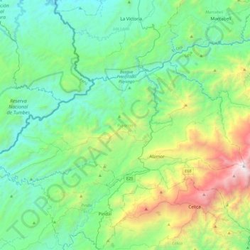
Name: Puyango topographic map, elevation, terrain.

Location: Puyango, Loja, 110406, Ecuador (-4.07385 -80.29565 -3.85621 -79.87161)

Average elevation: 2,740 ft

Minimum elevation: 522 ft

Maximum elevation: 10,072 ft

Other topographic maps

Click on a map to view its topography, its elevation and its terrain.

Yamballa

Ecuador > Loja > Loja > Vilcabamba

Average elevation: 6,207 ft

Algarrobillo

Ecuador > Loja > Celica

Average elevation: 2,913 ft

Cordillera del Huato

Ecuador > Loja > Paltas

Average elevation: 4,160 ft

Gear up for your next adventure:

🏔️Mountain Trail Maps - High‑detail maps for popular peaks
🔋Rechargeable Batteries - Power up your outdoor devices
🗃️Trail First Aid Kit - Essential kit for outdoor injuries and emergencies
🎒Trekking Poles - Sturdy poles for balance and stability on rough terrain
☀️Outdoor Sunscreen - High protection sunscreen for outdoor activities

As an Amazon Associate, this site earns from qualifying purchases at no extra cost to you.