
Make a donation
Gear up for your next adventure:
As an Amazon Associate, this site earns from qualifying purchases at no extra cost to you.
East Glenville topographic map
Click on the map to display elevation.
Make a donation
Gear up for your next adventure:
As an Amazon Associate, this site earns from qualifying purchases at no extra cost to you.
About this map
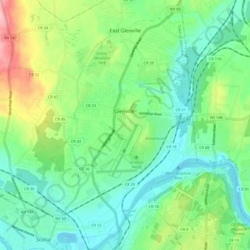
Name: East Glenville topographic map, elevation, terrain.
Average elevation: 344 ft
Minimum elevation: 197 ft
Maximum elevation: 702 ft
Schenectady County trails, hiking, mountain biking, running and outdoor activities
Make a donation
Gear up for your next adventure:
As an Amazon Associate, this site earns from qualifying purchases at no extra cost to you.
Other topographic maps
Click on a map to view its topography, its elevation and its terrain.
Lower Corners
United States > New York > Schenectady County > Town of Glenville
Average elevation: 673 ft
Stoodley Corners
United States > New York > Schenectady County > East Glenville
Average elevation: 351 ft
Make a donation
Gear up for your next adventure:
As an Amazon Associate, this site earns from qualifying purchases at no extra cost to you.
Rotterdam Junction
United States > New York > Schenectady County > Town of Rotterdam
Average elevation: 531 ft
The Stockade
United States > New York > Schenectady County > Schenectady > The Stockade
Average elevation: 269 ft
Make a donation
Gear up for your next adventure:
As an Amazon Associate, this site earns from qualifying purchases at no extra cost to you.
Bellevue
United States > New York > Schenectady County > City of Schenectady > Bellevue
Average elevation: 308 ft
Stanford Heights
United States > New York > Schenectady County > Town of Niskayuna
Average elevation: 348 ft
Pattersonville
United States > New York > Schenectady County > Town of Rotterdam
Average elevation: 502 ft