
吉木萨尔县 topographic map
Interactive map
Click on the map to display elevation.
About this map
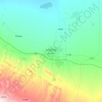
Name: 吉木萨尔县 topographic map, elevation, terrain.
Location: 吉木萨尔县, 昌吉回族自治州, 新疆维吾尔自治区, 中国 (43.83466 89.00886 44.15466 89.32886)
Average elevation: 2,762 ft
Minimum elevation: 2,001 ft
Maximum elevation: 5,184 ft
吉木萨尔县地势南高北低。南部为高山雪岭,北部为卡拉麦里山岭的低山残丘,两山之间是山前倾斜平原和低缓起伏的沙丘,最高点是二工河源头的雪峰,海拔500米。南部山区为以云杉为主的针叶林,四季常青。中部平原是重要的農業區,北部属古尔班通古牧沙漠。境内有主要河流10条,由西向东为二工河、西大龙口河、大东沟河、新地沟河、渭户沟河、东大龙口河、牛圈子沟河、吾塘沟河、小东沟、白杨河。
Other topographic maps
Click on a map to view its topography, its elevation and its terrain.