Geolocate

Auch topographic map

Click on the map to display elevation.

Auch

Auch has a minimum altitude of 115 metres (377 ft) and a maximum of 281 metres (922 ft). Its average altitude is 198 metres (650 ft), while that of its town hall is 134 metres (440 ft) The town and its surroundings have a hillside landscape.

Wikipedia (CC-BY-SA 3.0)

About this map

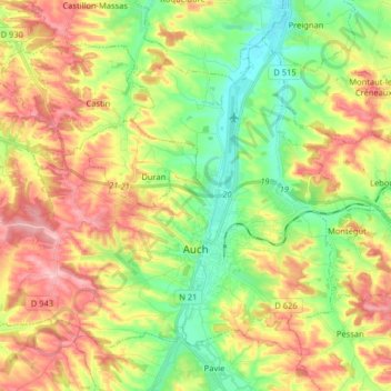
Name: Auch topographic map, elevation, terrain.

Location: Auch, Gers, Occitania, Metropolitan France, 32000, France (43.61719 0.48604 43.70772 0.64709)

Average elevation: 623 ft

Minimum elevation: 374 ft

Maximum elevation: 932 ft

Other topographic maps

Click on a map to view its topography, its elevation and its terrain.

Gascony

France > Occitania > Gers > Bazian

Average elevation: 1,348 ft

Pris

France > Occitania > Gers > Eauze

Average elevation: 502 ft

A las Costes

France > Occitania > Gers > Castelnau-Barbarens

Average elevation: 682 ft

Gear up for your next adventure:

📶Vehicle Signal Boosters - Improve reception in rural areas while driving to trailheads
🪶Compact Camp Shovel - Folding shovel for campsite tasks
🔊Portable Camp Speaker - Music and alerts at camp
🔥Camping Stove - Portable stove for camping and backcountry cooking
🏕️Family Camping Gear - Essentials for group camping trips

As an Amazon Associate, this site earns from qualifying purchases at no extra cost to you.