Geolocate
👉 Easily get elevation data in JSON, GeoTIFF and KML formats using Elevation API
Thank you for supporting this site ❤️
Make a donation

Candler topographic map

Click on the map to display elevation.

👉 Easily get elevation data in JSON, GeoTIFF and KML formats using Elevation API
Thank you for supporting this site ❤️
Make a donation

About this map

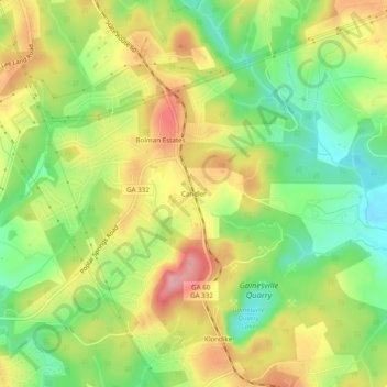
Name: Candler topographic map, elevation, terrain.

Location: Candler, Hall County, Georgia, 30507, United States (34.19038 -83.80129 34.23038 -83.76129)

Average elevation: 1,027 ft

Minimum elevation: 823 ft

Maximum elevation: 1,247 ft

Hall County trails, hiking, mountain biking, running and outdoor activities

Other topographic maps

Click on a map to view its topography, its elevation and its terrain.

Clermont

United States > Georgia > Hall County

Average elevation: 1,394 ft

Flowery Branch

United States > Georgia > Hall County

Average elevation: 1,125 ft

Don Carter State Park

United States > Georgia > Hall County

Average elevation: 1,161 ft

Gear up for your next adventure:

Camping Coffee Makers - Enjoy premium coffee at the summit or campsite
🔦Compact Flashlight - Reliable flashlight for emergencies
🧺Microfiber Travel Towels - Compact and fast-drying towels for trail use
🥾Women's Hiking Boots - Top-rated trail boots with ankle support and superior grip
🧷Carabiner Set - Durable clips for gear attachment

As an Amazon Associate, this site earns from qualifying purchases at no extra cost to you.