
Make a donation
Gear up for your next adventure:
As an Amazon Associate, this site earns from qualifying purchases at no extra cost to you.
Oyama topographic map
Click on the map to display elevation.
Make a donation
Gear up for your next adventure:
As an Amazon Associate, this site earns from qualifying purchases at no extra cost to you.
Oyama
Oyama is located in the far northeastern corner of Shizuoka Prefecture, bordering on Yamanashi and Kanagawa Prefectures. Located in between the Tanzawa Mountains and the foothills of Mount Fuji, the town has an average altitude of 800 meters, and has a cool climate with heavy rainfall. Some 65% of the town is covered in forest.
Make a donation
Gear up for your next adventure:
As an Amazon Associate, this site earns from qualifying purchases at no extra cost to you.
About this map
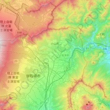
Name: Oyama topographic map, elevation, terrain.
Average elevation: 2,418 ft
Minimum elevation: 312 ft
Maximum elevation: 5,650 ft
Make a donation
Gear up for your next adventure:
As an Amazon Associate, this site earns from qualifying purchases at no extra cost to you.